|
Fahan Beehive Huts (Glenfahan), Co. Kerry
Location: Take the Slea Head Road (R 559) east from Dingle. Continue through Ventry and soon the road will
follow the coastline which showcases some very dramatic scenery along and across Dingle Bay. About 6.5 kilometers
east of Ventry, the road fords a stream (you will drive right through this shallow stream and the road takes a
rather sharp 120 degree bend). About a kilometer further, pass Dunbeg Fort on the left and the next public parking
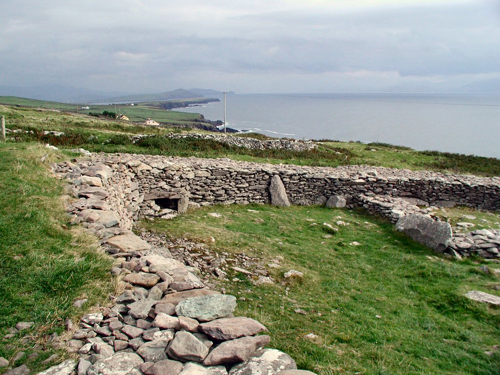
area will be directly across the road from the steep path that winds up to this complex of clochauns (stone
beehive-shaped buildings) on the southern slope of Mt. Eagle overlooking Dingle Bay with the Blasket islands off to
the southwest.
Dimensions: The central hut is the largest of this group with a diameter of 5.6 meters (inside dimension)
and a wall height of 2.25 meters. The entrance to the southeast has no roof and is now blocked by a modern stile.
The passage is 1.95 meters high and 2.75 meters long. There is a narrow lintelled passage to the east hut with paved
flooring 1.14 meters high and 2.25 meters long. The east hut is a little over 4 meters in diameter with a maximum
wall height of 2.25 meters (some of which may be have been rebuilt). There is another low lintelled passage from the
central hut to the smaller west hut. The passage is 1.3 meters high, 1.1 meters wide and 1.9 meters long. The
west hut is less than 3.5 meters in diameter and the walls are only about a meter high. Each of the huts have
lintelled wall niches of various sizes. The L shaped souterrain, not presently accessible, is under the
entrance stones to the central hut. It is said to have a passage of just over 3 meters ending in a chamber of
about 2.75 meters. Abutting the easternmost hut is a rectangular annex connected to the central hut by a paved
pathway. It measures approx. 1.5 x 2.5 meters and the walls are just over 1.5 meters high. This appears to be
of relatively recent construction and may have been used to contain small farm animals. Many of these structures
have been used as sheep and pig pens over the years.
Features: A triple clochaun of corbelled drystone (without mortar) construction with a souterrain opening
from the floor of the central hut and a rectangular addition on the southeast corner which may be a modern build.
Comments: The slopes of Mt. Eagle bear the remains of a number of these beehive huts, both isolated
structures or in compounds. This group is part of the National Monument Group and a small fee used to cover
maintainance is charged (2 euro in 2004). Because of the size of this stone fortress-like grouping, it is
difficult to get a good overall photograph. Other shots may have to have the modern telephone wires digitally
removed for more ambiance. Even though there was some extensive work done here by the OPW, the climb is well
worth the effort for the view. The huts and surrounding cashel are added bonuses.
History: Cuppage et al/1986, 203--204: `This oval cashel (National Monument no. 156/1--5) is situated on the
S slopes of Mount Eagle overlooking Dingle Bay. Much of its interior is occupied by a group of 5 roughly circular,
conjoined clochauns, and a 6th irregularly-shaped structure. A souterrain passage extends from one of these huts to
a chamber beneath the cashel wall. The site has been considerably restored by the OPW, and, during restoration work
in the 19th century, an elaborate cross-slab was discovered; this is now housed in the NMI. A fragment of a rotary
quern was also found lying loose within the cashel'.
Other Items of Interest: Looking over the walls of this cashel and further up the slope of Mt. Eagle, more
cashels can be seen, with clochauns in various states of ruin.
|